Zoning Tutorial for New Farming Enterprises
A Maryland FarmLINK Assistance Guide
Suburban Development and Zoning Impacts on Farming
Suburban Development and Zoning Impacts on Farming
Over the last 70 years or so, farmland acres have dwindled in most Maryland counties as suburban development extended into rural areas from Washington D.C., Baltimore, and Dover, Delaware. Along with suburbanization came commercial development. Gradually, farms, residential developments, and commercial businesses formed a quiltwork of land uses over broad expanses of rural counties.
As a result of the mix of land uses and the growing residential populations, many Maryland counties have adopted comprehensive plans to identify where new growth should be directed. They have built roads, community water and sewer, and public buildings to serve the new growth. Zoning regulations have been adopted to implement plans and address land use impacts. Prime farming areas have been identified to protect and sustain the remaining farming industry.
Meanwhile, farming has changed too. In the last 70 years, the introduction of commercial fertilizer meant that less land was needed to produce the same amount of grain. The introduction of and bigger and better equipment facilitated the aggregation of farmland by one farmer, thus the need for fewer farmers. Even as the number of farmers and farms declined, farm production increased. In Maryland, commodity (e.g. corn, soybean, and wheat) farms have gotten larger.
However, some farms have gotten smaller too. Vegetable and fruit operations produce higher income per acre and can operate on as little as a few acres. With increased demand for locally sourced food, the number of acres in vegetables and fruits has increased. Because of their smaller size, these farms are locating in suburban areas and even in towns and cities where they benefit from proximity to potential customers.
In addition, farmers have introduced new ways to raise revenue, such as wineries, horse stables, corn mazes and on-the-farm weddings. Such uses can bring an important revenue stream to a farm.
When non-residential uses adjoin residential development, residential owners sometimes complain of nuisances that affect the use and enjoyment of their land, such as noise, odor, dust, or visual blight. When residential development moves into agricultural areas, the new residents often raise concerns about tractors operating early in the morning, about farm equipment slowing down traffic, about dust or odors from animal operations etc. On the other hand, farmers sometimes raise concerns about trespass and vandalism, and about traffic that makes it difficult to move equipment from farm to farm.
Many of these concerns are addressed in comprehensive plans, zoning maps, and zoning ordinances.
Comprehensive Plans
Comprehensive Plans
Why should farmers care about comprehensive plans? A county’s comprehensive plan is its official policy document. It provides a “blueprint” or vision of how a county wants to grow in order to maintain or improve quality of life. The State reviews county comprehensive plans to determine whether or not to provide state funding for a local project (e.g. Rural Legacy Program, Community Legacy Program, roads, etc.) A comprehensive plan is required by state statute as a basis for zoning maps and ordinances. Therefore, farmers looking to buy or lease land or expand their operations on existing farmland should review comprehensive plans to determine if their new farm business or business expansion will be consistent with the county’s vision for the future.
County Zoning District Maps
County Zoning District Maps
Zoning district maps provide more guidance to farmers looking to buy or lease land or expand their operations. Zoning district maps implement comprehensive plans by creating land use zones that complement the visions, goals and objectives of comprehensive plans.
Farmers who plan to grow vegetables and fruits to sell directly to consumers may wish to locate in residential or commercial zones in or near towns to be near more potential customers. However, not all residential and commercial zones allow vegetable or fruit production and most prohibit more intensive agricultural endeavors.
For the purposes of this report, we are identifying where county zoning maps have identified farming as the principal and preferred use. Maps 1 – 5 portray zoning districts in Southern Maryland.
Anne Arundel County Zoning District Map
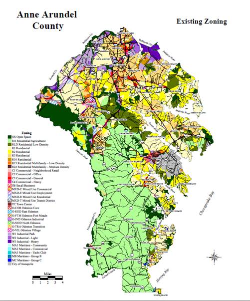
Residential Agriculture District, the area shown in light green, is the preferred zone for agricultural uses.
Map source: Anne Arundel web page, Dec. 2011. To find the most recent map, go to county web page.
The Anne Arundel County zoning map is online – HTTP://WWW.AACOUNTY.ORG/PLANZONE/RESOURCES/GISZONING.PDF
The County Codes are online – HTTP://WWW.AACOUNTY.ORG/COUNTYCODE/INDEX.CFM
The Zoning Code is Chapter 18.
Calvert County Zoning District Map
Farm and Forest District (FFD), the area shown in light green, is the preferred zone for agricultural uses.
Source: Calvert County web page, Dec. 2011. To find the most recent map, go to county web page.
The comprehensive plan is online- HTTP://WWW.CO.CAL.MD.US/DOCUMENTCENTER/VIEW/254
Zoning maps are online –
HTTP://WWW.CO.CAL.MD.US/INDEX.ASPX?NID=568
The zoning ordinance is online – HTTP://WWW.CO.CAL.MD.US/INDEX.ASPX?NID=567
Charles County Zoning District Map
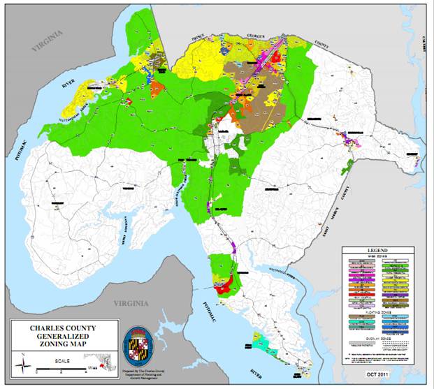
Agricultural Conservation District (AC), the area shown in white, is the preferred zone for agricultural uses.
Source: Charles County web page, Dec. 2011. To find the most recent map, go to county web page.
The comprehensive plan is online –
HTTP://WWW.CHARLESCOUNTYPLAN.ORG/
Zoning maps online – HTTP://WWW.CHARLESCOUNTYMD.GOV/PGM/PLANNING/ZONING-MAPS
Zoning ordinance is online- HTTP://WWW.CHARLESCOUNTYMD.GOV/SITES/DEFAULT/FILES/PGM/PLANNING/ZONING_ORD_1-2013.PDF
Prince Georges County Zoning District Map
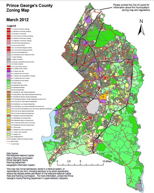
Residential-Agriculture (R-A), the area shown in blue-green, is the preferred zone for agricultural uses.
Source: MNCPC web page, Dec. 2011. To find the most recent maps, go to the county web page.
The zoning maps are online as well as a live interactive GIS map – HTTP://WWW.PGATLAS.COM
The zoning ordinance is online – HTTP://WWW.PGPLANNING.ORG/RESOURCES/ZONING_INFORMATION/ZONING_ORDINANCE_AND_USE_TABLES.HTM
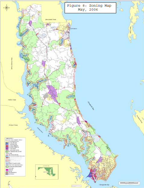
St. Marys County Zoning District Map
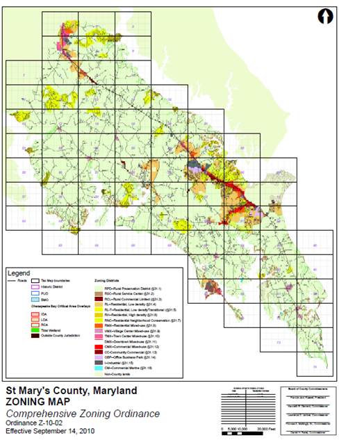
Rural Preservation District (RPD), the area shown in light green, is the preferred zone for agricultural uses.
Source: St. Mary’s County web page, Dec. 2011. To find the most recent map, go to county web page.
The comprehensive plan is online – HTTP://WWW.STMARYSMD.COM/DOCS/COMPPLAN.PDF
The aerial photos and zoning maps are online –
HTTP://WWW.CO.SAINT-MARYS.MD.US/GIS/
The zoning ordinance is online –
HTTP://WWW.CO.SAINT-MARYS.MD.US/DOCS/CURRENTZO.PDF
Zoning Ordinances and Other Land Use Restrictions
Zoning Ordinances and Other Land Use Restrictions
Most county zoning ordinances describe the county’s zoning districts and then provide a land use table or list which indicates where land uses are allowed.
Row crops and farm buildings are generally allowed in all rural zoning districts. More intensive farming practices that pre-date zoning, such as on-farm processing, are often allowed to continue as “non-conforming uses.”
Existing intensive farming practices may also be protected by Maryland’s “Right-to-Farm” Statute, which has been adopted by most counties. However, farmers are sometimes dismayed to learn that a new farming practice or value-added operation (such as a winery, a corn maze, or slaughtering facility) is a regulated or prohibited activity due to potential nuisances they may create, such as:
- Noise – i.e. a large grain mill located near a property boundary or music from an agri-tourism event
- Odor –such as that from manure piles or pits
- Traffic – from farm events or retail facilities on farms
Farmers should be looking for the following types of land use permissions:
Permitted Use (often shown as ‘P’ in the land use tables).
The use is allowed by the ‘base’ zoning district, but check with the county to find out if there are any special overlay districts (such as the Maryland Critical Area or Historic District) which further limit land use. Also, check to find if there are conditions listed elsewhere in the Ordinance for a land use that you wish to undertake.
Conditional Use (often shown as ‘C’ in the land use tables).
The use is allowed by the ‘base’ zoning district, subject to pre-defined conditions often listed elsewhere in the zoning ordinance. You should check with county staff to be sure that you find all conditions that will apply. Also watch out for special overlay districts as mentioned under Permitted Use.
Special Exception (often shown as ‘S’ or ‘SE’ in land use tables. In St. Mary’s, a use listed as ‘C’ requires Board of Appeals approval).
Board of Appeals approval is required before a Special Exception use is allowed. The Board of Appeals is a citizen board appointed by elected officials to rule on zoning cases related to land uses that may not normally be compatible with adjacent land uses.
Not Permitted (either not listed in the use tables or shown as an empty box or “X”).
If a use is not listed in the county’s zoning ordinance, it is possible that the use is deemed by the zoning officer to fall under the general definition of “farming” or under another land use definition which will allow the use on the subject property. In any event, if a use is not clearly defined and clearly permitted in the land use tables for the property, you should ask for a written interpretation from the county zoning officer and also raise the issue with your legal counsel prior to signing a contract.
Finally, check with the property owner, the realtor and/or the county to find out if the property is in a county or state Agricultural Preservation District or other program with a covenant or easement that will limit allowable land uses. Ask your legal counsel if it is advisable to ask for a title search in the county land records before a contract is signed.
Summary of Southern Maryland County Zoning Regulations
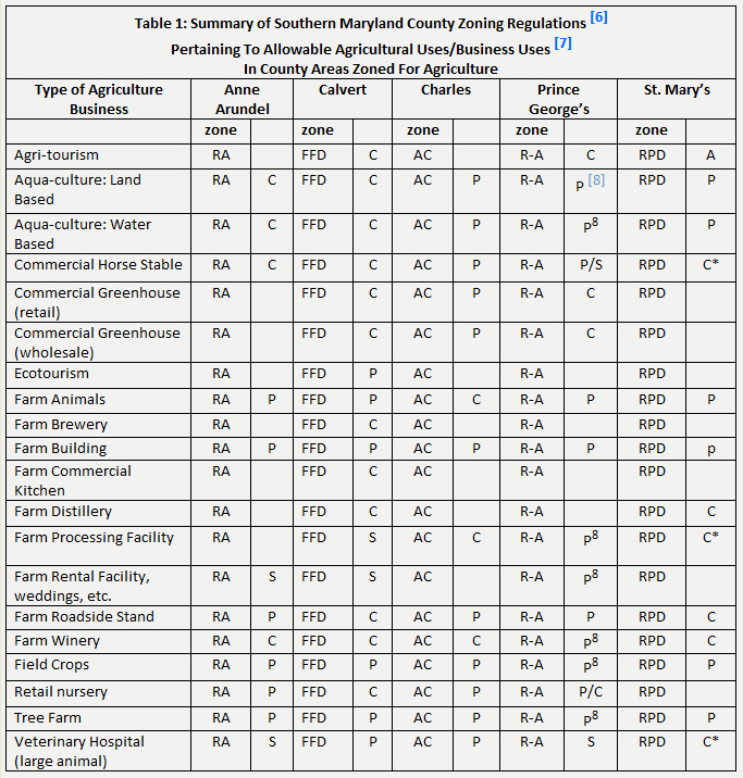
Table 1 is a summary of Southern Maryland County Zoning Regulations pertaining to allowable agricultural uses/business uses. It was compiled in early 2012 and land use terms and definitions vary. Check the zoning ordinance links below for the most current regulations posted by the counties. Also, check for overlay districts, such as historic districts or the Critical Area. If a property is designated with an overlay district, be sure to find out what approvals are needed if you wish to change the property in any way.
This summary was compiled in 2012 and Land Use Terms and Definitions vary. Check with current county regulations. Also check to see if conditions apply if a property is in an overlay district, such as the critical area.
Definitions and Interpretations
Definitions and Interpretations
In zoning ordinances, definitions are extremely important. Definitions clarify the intent of the elected officials when adopting the regulations and the definitions may differ from the common or dictionary definition of a term. The clearer the definition, the better protection it provides a farmer who spends time, money and effort starting a new farming venture from a neighbor who wishes to challenge the use in court.
If a farming practice is not specifically listed, it may still be allowed. The zoning official may interpret that it fits under the general definition of farming or under some other land use category. In that case, the farmer is advised to write to the zoning official and request a written interpretation.
Also, if you believe that your farm use is “non-conforming”, please be sure to check the zoning definition of non-conforming and check with the Zoning Officer to be sure that the use is allowed to continue and if it is allowed to be expanded.
Conclusion
Conclusion
One essential part of planning and developing a new farm enterprise is learning about the plans, maps, and zoning regulations of the county where you wish to locate. The plans establish a blue-print or vision for the county. The zoning maps show where agriculture land uses are preferred. The zoning regulations list where agriculture uses are permitted and under what conditions. These regulations vary from jurisdiction to jurisdiction.
We hope this tutorial helps to make your new farm enterprise a success.
Appendix: Suggested Letter to a County Zoning Department
To Whom It May Concern:
I have an interest in a __ acre farm in your county, located at (insert address here) .
Specifically, I would like to conduct the following farm operations (insert list of operations here.)
Please write to me to confirm the zoning district.
Also, please let me know if these uses are allowed and if any conditions must be met and what permits, if any, are required.
Thank you for your assistance
(signature)
Disclaimer:
The information in this site is intended for use as educational material to assist landowners, farmers, and their advisors in understanding various laws and zoning regulations. These resources are not intended, and should not be used, as legal advice. Landowners and farm operators should consult a lawyer and other relevant professionals prior to entering a lease agreement or purchasing property. Reasonable efforts have been made to ensure the accuracy of the information contained herein; however, the content and interpretation of laws and regulations are subject to change. Southern Maryland Agricultural Development Commission and the Tri-County Council for Southern Maryland disclaim all liability to any person for any loss caused by errors or omissions in the information. The use of these materials by any person represents an agreement to hold harmless the author, Southern Maryland Agricultural Development Commission and the Tri-County Council for Southern Maryland for any liability, claims, damages, or expenses that may be incurred by any person as a result of reference to or reliance on the information contained in this site.
LINKS TO ALL MARYLAND COUNTY AND BALTIMORE CITY COMPREHENSIVE PLANS, ZONING MAPS AND ZONING ORDINANCES (AS OF 4/2012)
Allegany
Comprehensive Plan
Zoning Ordinance
Zoning Map
Anne Arundel
Comprehensive Plan
Zoning Ordinance and Map
Baltimore
Comprehensive Plan
Zoning Ordinance
Zoning Map
Baltimore City
Comprehensive Plan
Zoning Ordinance
Zoning Map
Calvert
Comprehensive PlanZoning Ordinance
Zoning Map
Caroline
Comprehensive PlanZoning Ordinance
Carroll
Comprehensive Plan
Zoning Ordinance and Map
Cecil
Comprehensive Plan
Zoning Ordinance
Zoning Map
Charles
Comprehensive PlanZoning Ordinance
Zoning Map
Dorchester
Frederick
Comprehensive PlanZoning Ordinance
Zoning Map
Garrett
Comprehensive PlanZoning Ordinance
Zoning Map
Harford
Comprehensive PlanZoning Ordinance
Zoning Map
Howard
Comprehensive PlanZoning Ordinance
Kent
Comprehensive PlanZoning Ordinance
Prince George’s
Comprehensive PlanZoning Ordinance
Zoning Map
Montgomery
Queen Anne’s
Comprehensive PlanZoning Ordinance
Saint Mary’s
Comprehensive PlanZoning Ordinance
Zoning Map
Somerset
Talbot
Comprehensive Plan
Zoning Ordinance and Map
Washington
Comprehensive PlanZoning Ordinance
Wicomico
Comprehensive PlanZoning Ordinance
Zoning Map