Using the NRCS Web Pages to Get Soils Information
A Maryland FarmLINK Assistance Guide
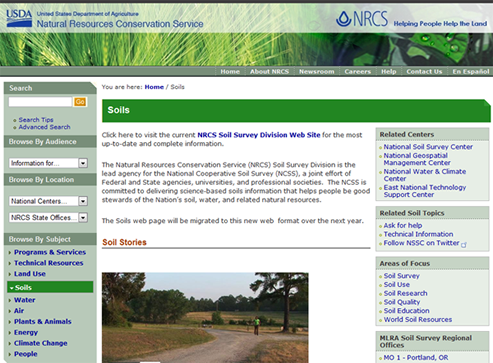
Figure 1 : NRCS Soils Home Page
The NRCS is a branch of the United States Department of Agriculture. The NRCS website provides the nation’s most comprehensive source for soils information with its posting of the National Cooperative Soil Survey, an effort of Federal and State agencies, universities, and professional societies to deliver science-based soil information. Included in the National Cooperative Soil Survey are digital soils maps, soil taxonomy, laboratory references, etc. which are used by academicians, scientists, engineers, developers and agronomists in their work.
Farmers and realtors may also find the soils information on the NRCS website to be very helpful in buying or selling land and in determining soil suitability for a variety of crops and other farm enterprises. NRCS has prepared a brochure which gives the basics for using the Web Soils Survey. You may want to print this out as well. It covers a wider range of resources than we cover in this guide.
The website uses basic Geographic Information System (GIS) tools and the brochure assumes that you have the skills or knowledge to use them. With our guide, we provide additional instruction for those who have may not have used these tools before. In the hope of making the process easier and faster, our goal is to help a beginner do just three tasks:
- create a soils map of a property,
- find out what the soils categories mean, and
- find soil suitability classes for farming.
Getting Started
To begin, either print out these instructions and left click on the following URL or right click on the URL and open a second tab so that you can have both the instruction and the websites on your screen.
The National Cooperative Soil Survey is a compendium of resources for many fields of study. Farmers and realtors interested in creating a soils map of a property and learning what that information means, may want to begin with the page shown in Figure 2 – Web Soil Survey.
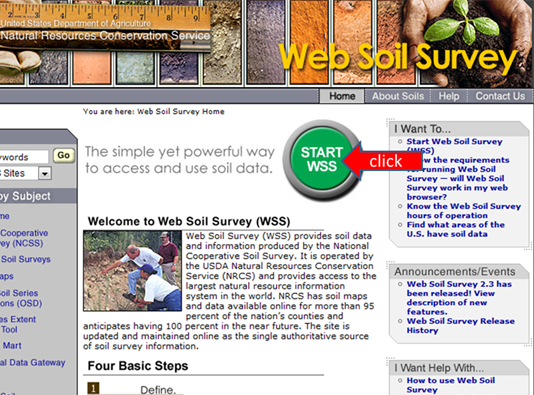
Figure 2 : Web Soil Survey
Creating A Soils Map
The first step in creating a soils map is to left click the mouse over the green “START WSS” button as shown in Figure 2. Users wishing to create a soils map for a property are now instructed to define an “Area of Interest (AOI)”. There are a number of ways to define the AOI. For occasional users of the site, the best way might be to click on “Address”. When you do so, address fields are opened. For this example, we have used a portion of Maryland’s Jefferson Patterson Park and Museum property in Calvert County located at 10515 Mackall Road, St. Leonard, MD 20685. Fill in the address and then click “View” (see figure 3). By doing so, you are accessing the large WSS data base. If your internet connection is slow, this might take a few minutes.
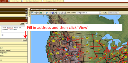
Figure 3 : Defining Area of Interest
At this point, you might need to use the icons in the upper left of the map to zoom in (+), to zoom out (-), or use the hand iconto move the entire field or farm to the center of the screen. After you have clicked on an icon, the action is initiated when you move your cursor over the map and click the left side of the mouse. Again, if your internet connection is slow, it may take a minute or two for the new view to appear. Properly locating the AOI may be the longest part of the job. Once the entire field or farm is clearly visible on your computer screen, the next step is to create a boundary outline of the property. Click on the button where the red arrow is pointing in Figure 4. By using the cursor, you can create a boundary of the property of interest, which becomes your Area of Interest (AOI).
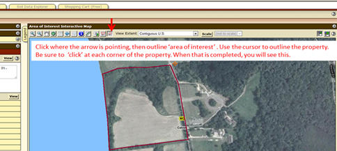
Figure 4 : Area of Interest Interactive Map
To begin, place your cursor at a corner of the property and click on the left side of your mouse. Then move your cursor to the next property corner or turn and left click the mouse. Continue to move the cursor around the outer boundary of the entire property, and left click at each turn. When you return to the original starting point, “double click” the left side of the mouse and a new image will appear (see figure 5).
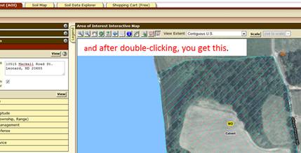
Figure 5 : Area of Interest Boundary Defined
Next, click on the “Soil Map” tab and the map will appear on the right (see figure 6 below). On the left will be a breakdown of soil types, acreages, and percentage. Another useful resource is that by clicking on each soil type listed under “map unit name” in the Map Unit Legend, you can view a thorough description of each soil type (which you can print out).
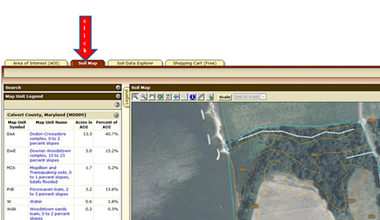
Figure 6 : Soil Map
Learning About Land Capability Classifications
These digital maps are very helpful, as long as the boundary lines are accurately outlined. The map unit not only identifies the soils, it estimates the degree of slope of the soil profile and the percentage of that soil type over the entire AOI. Taking a look at the soils types in the map unit legend in the example in Figure 6, you will find “Dodon-Crosiadore complex” (DeA) soils listed at the top. If you are not a soils scientist, chances are you won’t know the limitations of DeA soils. So the next step is to learn about the soils capability classifications.
To access this information, follow steps 1-4 outlined in Figure 7. A map and table is produced which lists the soils on the property along with soils classes. Soil classes range from 1 through 8, with Class 1 having the least limitations for field crops and Class 8 which has limitations that preclude commercial plant production. The map is shown in Figure 7 and the table ‘summary by map unit’ is shown in Figure 8.
The Land Capability Classifications (ratings) are often used to determine if a property can qualify for state and local land preservation programs. Soils classes 1 – 3 are often categorized as prime soils and many land preservation programs require a percentage of a farm to be prime soils to qualify.
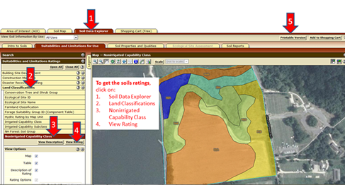
Figure 7 : Steps to determine the Soils Capability Classifications
Your soils report can now be printed. First, click on “Printable Version” (see red arrow 5). Customize the subtitle of the report if you wish and click on “View”. Then RIGHT CLICK on “printable Version” and then click on “Print” and follow the instructions. You may need to adjust the layout from ‘portrait’ to ‘landscape’ before hitting the print button.
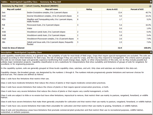
Figure 8 : Land Capability Classifications from the National Cooperative Soil Survey
Conclusion
Farmland soils are the key to the success of a farm and may be the key to the success of a farm sale or lease. Land owners, realtors, and those interested in buying or leasing are wise to know about the soils of a property which are available from the National Cooperative Soil Survey.
Soil Conservation Districts
Soil Conservation Districts Fact Sheet
Soil Conservation Districts are an important partner for farmers. Download this fact sheet or see below for local district contact information.
Anne Arundel Soil Conservation District
Heritage Office Complex, 2662 Riva Road, Suite 150, Annapolis, MD 21401
Phone: 410-571-6757
Website: aascd.org
Email: info@aascd.org
Calvert Soil Conservation District
489 Main Street, Prince Frederick, MD 20678
Phone (410) 535-1521, ext. 3
Website: calvertsoil.org
Email: calvertsoil@calvertcountymd.gov
Charles Soil Conservation District
4200 Gardiner Road, Waldorf, MD 20601
Phone: (301) 638-3028
Website: charlesscd.com
Email: info@charlesscd.com
Prince George’s Soil Conservation District
5301 Marlboro Race Track Road, Suite 100, Upper Marlboro, MD 20772
Phone: 301-574-5162 ext.3
Website: pgscd.org
Email: pgscd@verizon.net
St. Mary’s Soil Conservation District
26737 Radio Station Way, Suite B, Leonardtown, MD 20650
Phone: (301) 475-8402 ext. 3
Website: stmarysscd.com
Email: info@StMarysSCD.com
